Artificial Intelligence | Online Workshop | English | Asia-Pacific
Description:
Urban safety perception has long been studied from the perspective of active measures such as patrolling, adequate lighting at night, and fast grievance addressal systems. The use of machine vision allows designers to interrogate how urban fabric affects safety perception, and consequently design interventions that may increase perceived safety. This 2-day workshop is designed to be an introduction (for the uninitiated) to the use of machine vision and machine learning in addressing the age-old question of “How to quantify subjective spatial experience?”
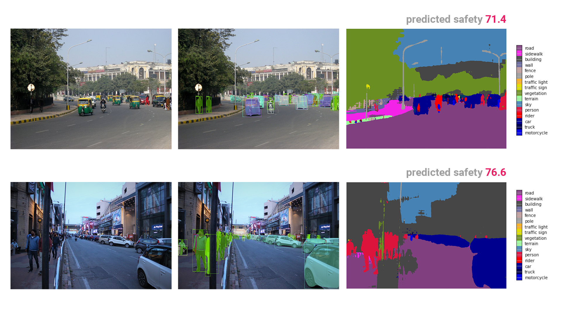
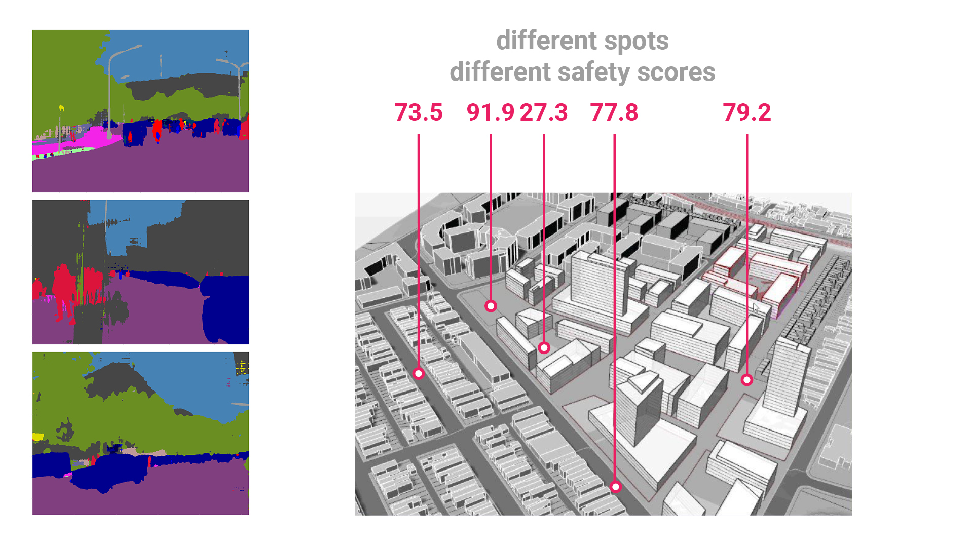
Participants will be introduced to the theories of machine vision and different machine learning techniques. As part of the exercise, machine vision algorithms such as semantic segmentation and object detection will be used to extract and quantify urban features (e.g., road, people, trees, vehicles, sky, building, etc.) from geo-located photographs of urban scenes. Subsequently, using an appropriate data-collecting method, participants will be asked to rate the photographs on a Likert scale of ‘very safe’ to ‘very unsafe’. On the other hand, keyword(s)-driven subjective reviews of the geo-locations of the photographs will be scraped from the web using pre-written code. The corresponding information of the urban features and safety scores of the photographs will be analysed to extract urban design principles. Finally, using the same dataset, different machine learning algorithms (non-linear regression, random forest regression, and regression neural network) will be trained to predict the safety perception of new (designed or speculative) urban scenes.
The use of machine vision and machine learning opens the possibility of statistical assessment of multivariate urban spatial information. Additionally, using crowd-sourced data marks a departure from the top-down evaluative guidelines published by experts to a more inclusive bottom-up evaluation by end-users. The methodology can be later used by the participants to assess other subjective criteria, e.g., urban beauty.
Key Words:
Urban safety,Machine vision,Machine learning,Data analytics
Required Skills:
No specific skill needed, basic coding skill will be an added advantage
Required Software:
Rhino + Grasshopper, Google Colab account, Photoshop
Required Hardware:
Personal PC or laptop
Maximum number of participating students:
30
Participants will be introduced to the theories of machine vision and different machine learning techniques. As part of the exercise, machine vision algorithms such as semantic segmentation and object detection will be used to extract and quantify urban features (e.g., road, people, trees, vehicles, sky, building, etc.) from geo-located photographs of urban scenes. Subsequently, using an appropriate data-collecting method, participants will be asked to rate the photographs on a Likert scale of ‘very safe’ to ‘very unsafe’. On the other hand, keyword(s)-driven subjective reviews of the geo-locations of the photographs will be scraped from the web using pre-written code. The corresponding information of the urban features and safety scores of the photographs will be analysed to extract urban design principles. Finally, using the same dataset, different machine learning algorithms (non-linear regression, random forest regression, and regression neural network) will be trained to predict the safety perception of new (designed or speculative) urban scenes.
The use of machine vision and machine learning opens the possibility of statistical assessment of multivariate urban spatial information. Additionally, using crowd-sourced data marks a departure from the top-down evaluative guidelines published by experts to a more inclusive bottom-up evaluation by end-users. The methodology can be later used by the participants to assess other subjective criteria, e.g., urban beauty.
Schedule:
Jun 26 - Jun 27
-
Day 1 / Jun 26
-
Day 2 / Jun 27
Instructors:
-
 Joy Mondal WEsearch lab, SPA Delhi, CEPT University,Founder & Design Head, Visiting Faculty, Visiting FacultyJoy Mondal leads WEsearch lab which offers design computation consultancy to architecture practices in South-east Asia. He has released Grasshopper plugins to automate column-beam placement (Eelish) and to generate Piet Mondrian inspired 2D composition and 3D massing (Chingree). Joy is a TEDx fellow, presenting ways of democratising architecture for everyone by using graph theory and shape grammar to automate residential design generation, thereby making design service more affordable. He was the recipient of the inaugural Saint-Gobain research scholarship. His research has been published in various international CAAD conference proceedings including at ICETAD, SIGRADI and ASCAAD. He has taught subjects related to parametric design and AI in architecture at SPA, Delhi and CEPT University, Ahmedabad; and tutored at multiple international workshops including at Digital FUTURES 2020, ASCAAD 2021 hosted by The American University in Cairo, CAADRIA 2021 hosted by The Chinese University of Hong Kong and SimAUD 2021 hosted by University of Southern California.
 -
 Rohit Priyadarshi Sanatani School of Planning and Architecture, New Delhi,Assistant ProfessorRohit's research adopts computational approaches for the analysis of human emotional response to spatial and urban environments. His work explores the application of machine intelligence for the predictive modeling of spatial and urban affect. His past research directions have focused on the synthesis of machine learning driven frameworks for real-time affect analysis in early stage design. Rohit's professional work has involved multiple masterplan development and architectural projects across India. As an academic, he has conducted graduate courses on urban history, research methods and on empirical approaches to urban experience. He is currently associated as Assistant Professor at the School of Planning and Architecture, New Delhi.